
Layers from header section of the portal displays a list of map layers from the repository of Maharashtra Housing & Area Development Authority. Map Layers are mechanisms used to display geographic datasets on map and are fundamental units while doing analysis on map. They contain points, lines or polygons to define datasets on a map.
Click on
Layers to view its respective
window on the screen.
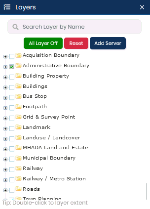
The Layers window consists of the following functionalities:
All Layer Off - This function allows the user to switch all the layers off on the screen.
Reset - This function will rearrange the layers on the map into its original state.
Add Server - This function allows the user to add WMS or WFS using URL.
Search - This function allows to search desired layer by specifying layer name in the search field.
Set Transparency
- This
function allows to set the transparency of any particular layer, use
the slider  corresponding to the layer name.
To
view specific layers on the map, check-in the particular checkbox.
For example - To view Administrator layers on the map, check-in Administrative
Boundary checkbox
from the Layers window.
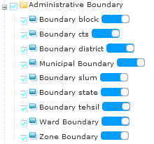
Click
on the  icon to expand
and view the layers.
icon to expand
and view the layers.
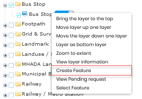
Create Feature- To create a new feature of a layer in the layer tree of the Citizen portal, follow the below mentioned steps:
Right-click on the desired layer from the Layer tree in the Layers tab.
Click
on Create Feature from the
available options in the list.
Create Feature dialog box pops-up on the screen. The dialog box provides
drawing tools to draw features on the map.
Pan
and zoom into the map to set an area of interest. Click on  icon from Create Feature
dialog box to draw a point feature on the map.
icon from Create Feature
dialog box to draw a point feature on the map.
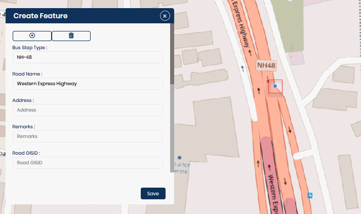
Specify all the necessary details regarding the feature drawn on the map and click on Save to add the newly created feature in the Layer tree. As a result, a request will be successfully generated for approval and a table of pending feature requests can be viewed as well. You can edit or delete any particular request from the table, if required.
View Pending Request- To have a look at the pending feature request list by users, right-click on the desired layer from the Layer tree and select View Pending Request.
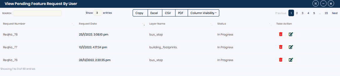
Table Functions:
To edit the feature
request, click on  icon from the corresponding rows.
To delete any
particular feature request, click on  from
the corresponding rows.
from
the corresponding rows.
The table allows you to export the tabular data into the Excel, CSV and PDF file formats.
You can copy the entire table by using Copy function.
To manage visibility of columns, click on Column Visibility and select desired columns to hide them from the table.
Search option allows you to filter out specific request from the table.
Show entries allows you to select the number of entries that are listed in the table.
Select Layer- You can add a feature in the selected layer, share the feature via E-mail and download the same in different file formats. Follow the below mentioned steps for better understanding:
Right-click
on the desired layer from the Layer tree and click on Select
Layer option. A Selected Layer bar appears on the screen.

Select either Point or Line or Polygon option and set an area of interest on the map to plot the same.
Click on Zoom option to zoom out of the map view.
In case you want to share the drawn feature with any other user, click on Share Map option. You can either Copy and paste the website URL or share the website link via E-mail.
Click on Download to save the feature in either KML or KMZ file formats.